Background Information
Hi, I'm Stephen Chalmers. What’s your name?
Parler Locator is a project blending art, programming, and data science -- reflecting on the digital breadcrumbs we leave behind as we go about our daily lives. Using a large scraped data set, it allows a proximity search based on your location to find the closest geotagged Parler video posts to your location. These posts are from before the initial iteration of the network was deplatformed in 2021, following the Capitol Hill riots.
Why I built this
In early 2023, I began researching on Parler as part of writing a chapter Selfies, Biometrics, Geolocation, and the 2021 Capitol Hill Riot: How Photography is Used in the Service of Surveillance in The Routledge Companion to Photography, Representation and Social Justice.
With my background in cinema and photography, while reviewing the information from Parler, I was struck by how many images and videos were geotagged. A recurring theme in my chapter was how images, metadata, and platform design decisions can aid in identification and surveillance—particularly in light of the advances in automated facial recognition technologies, which began with the foundational research by Bledsoe, Wolf, and Bisson in the 1960s. Note: Photography, since its inception in the late 1830s, has been used in the aid of identification and surveillance; however, fully automated facial recognition methods were theoretical in the 1960s and became more advanced decades later with developments in machine learning and algorithmic techniques.
This side project is meant to make one small slice of that story concrete, while being explicit about what the data can and cannot prove.
Try it
Go to the Locator, enter an address (or use browser location), and return the nearest geotagged posts.
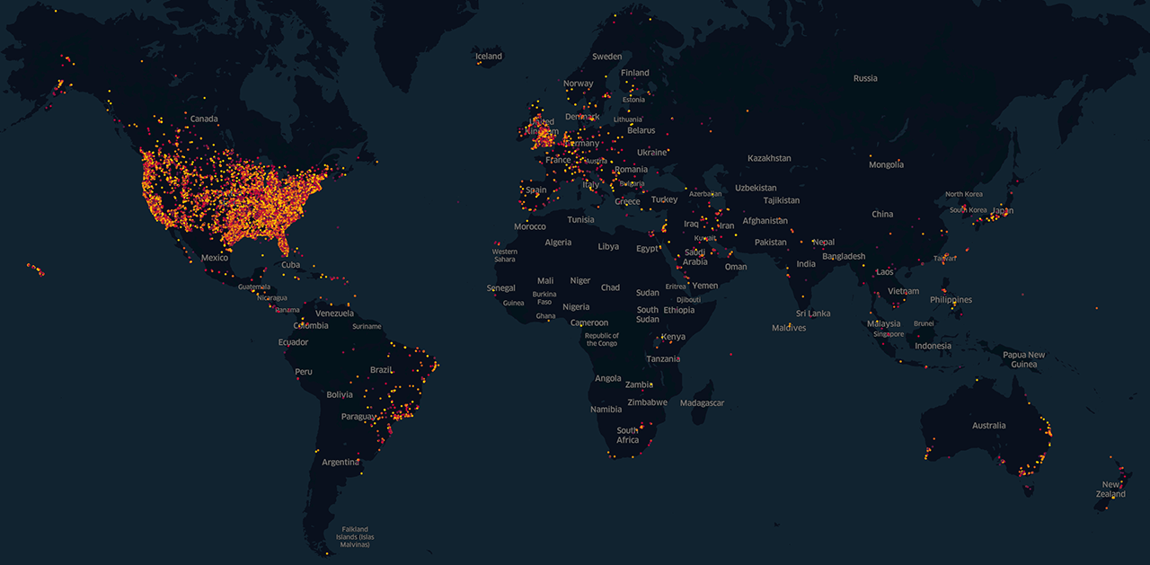
Geotagged post distribution
A GIS map of posts in the cleaned dataset. Click to view full size.
Parler in brief
Parler launched in August of 2018 and positioned itself as a “free speech” alternative (meaning fewer content policies) to other social platforms. In 2020, the platform saw a surge in use alongside a rapid increase in false information about election integrity leading up to the U.S. presidential election. Many users flocked to the platform, believing it provided a platform for unfettered conservative political discourse - while others viewed the network as amplifying extremist, racist, sexist and violent content, along with conspiracy theories.
After the storming of the U.S. Capitol on 6 January 2021, Parler faced scrutiny for hosting posts that supported or encouraged violence. Apple and Google removed the app from their stores, and on 10 January 2021 AWS terminated hosting services, taking the platform offline.
@donk_enby and the public archive
Prior to deplatforming, a user known as @donk_enby publicly described archiving a large portion (~8TB, or ~99% of the publicly available data uploaded to the platform) of Parler’s video content, citing weak URL design and a lack of rate limiting.

Capitol riot context
Of the geotagged videos, reporting identified ~618 videos that were directly linked to events at the U.S. Capitol on 6 January 2021. Those and other videos were referenced in investigations, prosecutions, and public reporting related to the breach.
Coding, data, and distance math
Of the 1.1 million videos in the downloaded dataset, approximately 6% (or ~64,520 videos) contained geolocation data. This web-based application searches through those videos to find the closest geotagged in reference to your location.
The cleaned dataset stores latitude/longitude to four decimal places. In North America that is roughly 11 meters / 36 feet of precision, ignoring GPS error and device metadata issues.
The locator page geocodes your input, then computes distance between your point and every post using the Haversine formula. Haversine is a spherical great-circle approximation of distances. Although the Earth is not a perfect sphere, this formula is practical and provides accurate results for the short distances this tool typically compares.
Dataset boundaries
A nearby coordinate does not necessarily indicate participation in a specific event. Geotagging can be inaccurate, posts may be unrelated, and coordinates might reflect incidental travel or faulty device metadata.
Treat this as a programming and mapping exercise, and as a prompt for thinking about metadata, platforms, and how “incidental data” can be repurposed.